- Screen Colours:
- Normal
- Black & Yellow
|
ƒ: Friday Street ⬉ 1¼ miles near A12 |
|
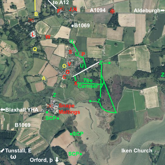
Λ MAP 1: Most of Snape Parish (and the area around Snape Maltings), A similar, but more whimsical view can be seen here, but not to scale. |
|
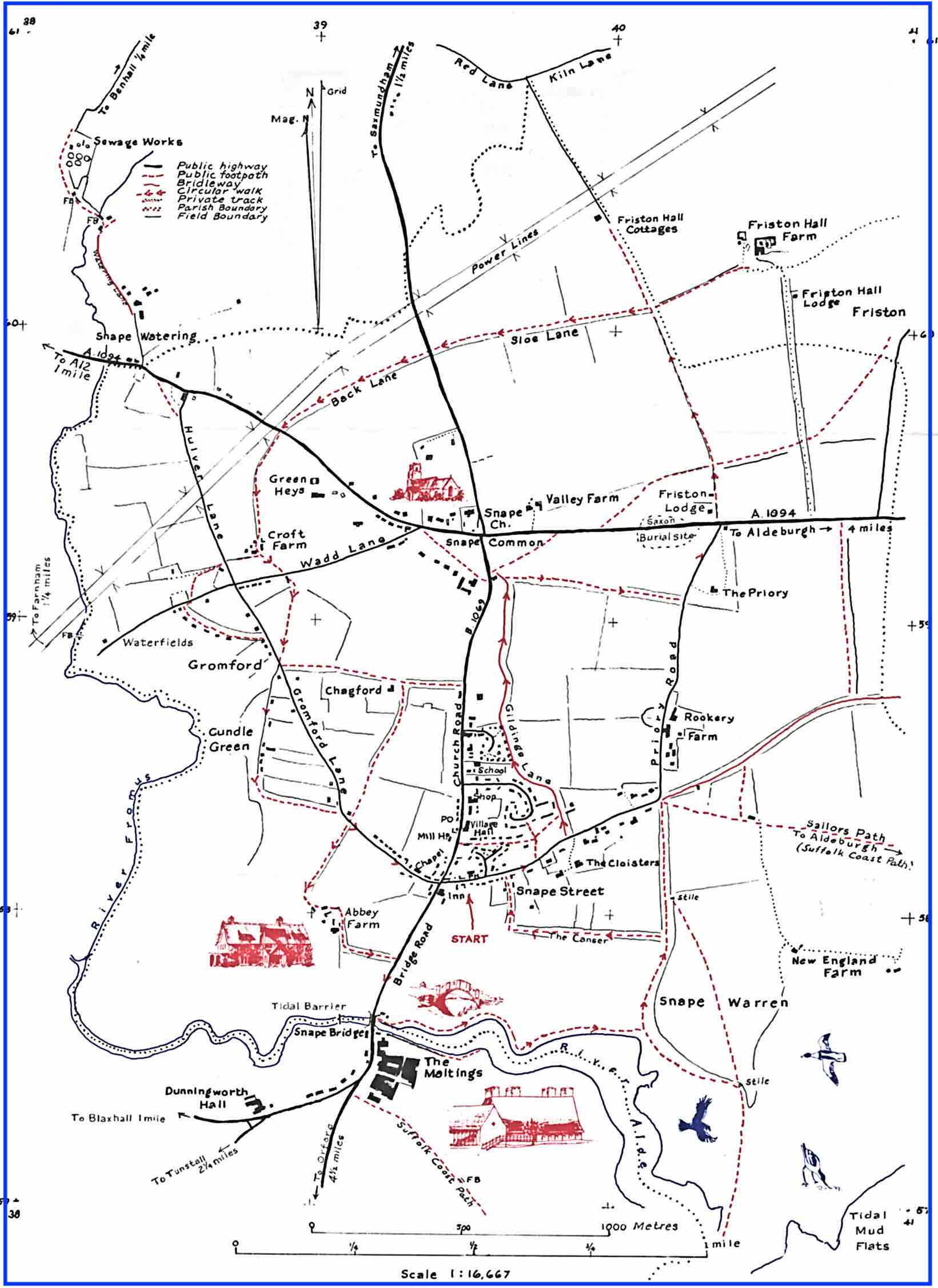
MAP 2: A map of part of the main village, showing more points, is here. |
| Distances of interest to visitors below are usually measured | |||
| from Snape Bridge (beside Snape Maltings), | |||
| which is 0.6 miles (1 km) south of the Village Hall (marked "V"). | |||
| A blue "f" below links to the business's Facebook page, | |||
| whilst a blue "map" text displays a what3words location. | |||
| ☞ maps | |||
| A | The Summer House in Snape at Abbey Farm: self-catering | 1,5 | map |
| B | Croft Farm: self-catering/caravan site (A1094, 1¼mi ⇄A12) | 1 | map |
| C | The Crown at Snape pub | 1,2,5 f | |
| D | Word on the Street: Snape Micro Library | 2 | map |
| E | equine facilities: Tunstall Forest Livery, IP12 2JY 1.6mi SW | ⬅1 | |
| F | filling station and shop: Church Garage (A1094) | 1 | |
| ƒ | Friday Street Farm Shop, IP17 1JX: 1¼ miles near A12 | off1 | f |
| G | Golden Key Inn pub (with bottle bank in car-park behind) | 1,2 | f |
| I | Iken Church IP12 2ES GR=TM412566 52.155°N 1.525°E | 1 | map |
| J | Church of St John the Baptist — "Please feel at home" | 1,5 | |
| L | Ladybird Nurseries garden centre | 1 | map |
| M | old Methodist Chapel (founded 1862; closed 2008) | ⬅2 | |
| N | notice-boards with village news and information | 2 | |
| O | Old Mill B&B (Hudson's, Benjamin Britten's former home) | 1,2 | |
| P | Playing Field at The Glebes, IP17 1QF | 1,2 | |
| ✉ | postboxes (3 central-village boxes on map 2; 3 more on map 1, left) | ||
| þ | Pump Street Bakery, Orford, IP12 2LZ (5½ mi/9km) | 1⬇︎ | f |
| Q | Squirrel Cottage self-catering | 1 | map |
| R | repairs, car/van hire: Snape Motor Co (B1069) | 2 | |
| S | Snape Community Primary School, Church Rd, IP17 1QG | 1,2 | |
| ⁜ | site of Snape Ship Burial (by A1094, ½ mile E of church) | 1 | |
| T | Tennis Court (south-east corner of Playing Field P) | 2 | |
| U | Guilding's Lane (bridleway) | 1,2 | |
| V | Village Hall, DEFIBRILLATOR, Post Office, Snooker Club | 1,2 | map |
| ω | Walk Farm B&B, Tunstall, IP12 2JX (2 mi/3.3km SW) | ⬅1 | |
| W | Priory Wood (2005; now cared for by GreenSnape) | 1 | |
| X | corral at west end of The Carnser path (meeting point) | 1 | map |
| Y | YHA Blaxhall (1½ mi/2.4km west of Snape Br.) camping | ⬅1 | |
| Z | Sailors' Path (part of SCP) 5.8 mi/9.3km to Aldeburgh | 1,2 | |
| SCP | Suffolk Coastal Path (section south of the Maltings) | 1 | |
Click on the relevant icon below for other maps … |
||
 |
 |
 |
| footpaths | dog-bins | historical |